
Planning Document
| 1. Overview |
| | Index | Overview | Harlem Piers | Harlem on the River | Next Steps | Appendix A | Acknowledgements | |
The Harlem Piers is located in Northern Manhattan between St. Clair Place, the Hudson River, 133rd Street and Broadway. It is a place with stunning panoramic views of the Hudson River, Palisades and George Washington Bridge. It is nestled between Riverside Park to the north and south. The area has an IRT subway station, three New York City Transit Authority bus routes and immediate access to the Henry Hudson Parkway. It is a place were people fish during warmer months. The area is home to the famed Cotton Club and it is within walking distance to some of Manhattan's most prestigious academic institutions: Columbia University, City College, Manhattan School of Music, Union Theological Seminary and Jewish Theological Seminary. Despite these extraordinary assets, Harlem Piers is one of a few places along Manhattan's waterfront that remains underdeveloped.
While development, open space or waterfront access exists or is underway along most of Manhattan's waterfront (to date, more than $350 million has been committed to build a new park along the waterfront below 59th Street), the Harlem Piers area is dominated by meat-packing establishments, semi-industrial and auto-related uses, parking, storage and warehouse uses. Instead of uses that would acknowledge and encourage public interaction with the waterfront, the area is surrounded by a sewage treatment plant, a waste transfer station and a bus depot. Fairway, a successful and popular wholesale retail market located in the area, currently uses a substantial portion of the waterfront area for customer parking.
Over 35,000 people, or 12,700 households, live in the surrounding area. Almost 30 percent of the population is under the age of 20. The ethnic composition of the area is mixed, consisting of Hispanics (53%), African-Americans (39%), and Whites (5%).
Recognizing the enormous opportunity to improve the environment and promote economic and sustainable community growth, two community organizations, West Harlem Environmental ACTion, Inc. (WEACT) and Manhattan Community Board 9 (CB 9), sought funding to initiate a three phase planning process to guide development along the waterfront. In 1998, the U.S. Department of Energy agreed to fund a community-driven planning effort to develop a plan for the Harlem Piers area called Harlem on the River.
Three-phase planning process for Harlem on the River consists of:
| Phase 1: | Develop a community vision with three parts - a concept plan for the Harlem Piers area (larger study area), Harlem on the River area (smaller study area) and the waterfront area. Produce a planning report and poster-sized illustrations of the concept plans, develop green building design standards and hold an exhibit showcasing the planning process. |
| Phase 2: | Undertake a zoning and traffic analysis to test the Harlem on the River recommendations, meet with public, private and non-profit property owners to development opportunities and meet with city agencies to discuss implementation strategies and seek approvals. |
| Phase 3: | Secure development funds, development entities and start implementation and construction. |
To carry out Phase I, the project sponsors, WEACT and CB 9, hired a planning firm and a landscape architectural firm to lead a community-driven planning process that included the participation of elected officials, community leaders, local development corporations, banks, local residents, merchants and institutions. During the 12-month planning process, the 40-member steering committee met regularly. A diverse group of 150 participants attended community forums and walking tours and over 140 people participated in a community design workshop. Consultants, with feedback from the steering committee and community, synthesized ideas and produced an illustrated report and poster plan. The planning process and final plan was unveiled at an exhibit that not only featured the final plan, but also showcased the sketch plans developed at a community design workshop (a.k.a. charette).
The Harlem on the River community planning process serves as a shining example of how stakeholders from various backgrounds and different interests can come together in a collaborative process to mutually develop a common vision for an area that has historically generated a lot of controversy. The community-driven planning process is one that should not only be promoted, but replicated.
The Community Planning Process
Steering Committee
A steering committee of elected officials, community leaders, businesspeople, local development groups and organizations was formed to assist with the direction of the community planning process. The steering committee met regularly to assist with community outreach, the development of the community design handbook, and the revision of plans developed by the design teams. It then selected the elements to be included in the final concept plan. The steering committee was open to any individual in the community willing to participate in the project.
Public Meetings
Two community meetings were held. The first meeting, held in March 1999, introduced the public to the planning process. The second meeting, in June 1999, provided the public with an opportunity to comment of the draft concept plan.
Community Design Workshop Handbook
To assist the community planning team with the development of a vision, the consultants and the steering committee developed a handbook that outlined the community design workshop goals, the purpose of the study, and background information about the Harlem Piers area. In addition, several base maps were prepared to aid the teams in their design process.
Community Design Workshop
In April 1999, about 140 people arrived at the Great Hall at City College to participate in the community design process. Nine teams were formed. Each team was led by one or two design professionals. During the daylong workshop, the room was electrified with creative energy as designers, residents, businesspeople and students sat around tables to sketch out their vision for the future of Harlem Piers. At the end of the day each team was given an opportunity to outline its planning philosophy, offer key recommendations and present a sketch of its vision. The ideas were thoughtful and creative. Many of the ideas ultimately influenced the final concept plans.
Plan Development
While the concept plan was being finalized and the report written, the consultants worked with the project sponsors to develop an implementation strategy (see Chapter 4: Next Steps). The implementation strategy outlined the steps to be taken to advance the concept plan.
Exhibit
In October 1999, an exhibit was held to officially release the final plans and report, as well as to showcase the evolution of the community planning process. The exhibit was held to celebrate the final plan that earned consensus praise from various groups in the community and to launch the implementation campaign to help realize the vision. The plans generated by the nine teams at the community design workshop were introduced and displayed.
| 2. Harlem Piers: Yesterday and Today |
| | Index | Overview | Harlem Piers | Harlem on the River | Next Steps | Appendix A | Acknowledgements | |
The Harlem Piers area was first developed in the early 1900's with the arrival of the IRT and IND subway lines and resulting residential and commercial development. Large industries (e.g. Interboro Coal Company and McCormack Sand Company) and warehouses utilized the piers between 131st Street and 133rd Street, and the rail line between Riverside Drive and Marginal Street, which are presently used by Amtrak, provided freight service to the entire West Side of the piers, including the various meat-packing operations located in the area. The western end of St. Clair Place was used as a recreational venue and the Palisades Ferry and various other Hudson River excursion boats used the piers as their termini.
Construction of the George Washington Bridge and the Henry Hudson Parkway in the 1930s and 1940s meant the end of ferry and rail service in the Harlem Piers area. Industrial businesses were relocated and the piers themselves began to deteriorate. The elevated Parkway isolated the riverfront from the neighborhoods above, leading to the eventual demolition of the recreational pier in the late 1950's. The meat packing industry had retained a solid presence in the area until recently, but competition from Hunts Point has triggered a slow decline, with many of the old meat packing buildings now abandoned, dilapidated or converted to alternate uses.
Since the 1970s, a number of ideas have been advanced for the Harlem Piers area, however, not one has been realized. Access to the river has increased north and south of the Harlem Piers area, but it remains one of the few underdeveloped areas along the Hudson River. Fairway, a wholesale/retail food market is currently using a large portion of the waterfront for parking. This has generated some community controversy as to the best use of this prime riverfront property. The Harlem Piers area continues to be one of Harlem's prime development sites. To address this opportunity, the New York City Economic Development Corporation (EDC) released a Request for Proposals to solicit developments for the waterfront west of 12th Avenue from St. Clair Place to 131st Street.
The Harlem Piers area has been the subject of many studies and development proposals, which include Port Harlem, Harlem-on-the-Hudson and Academy Plaza Plan. All of these plans recognized the enormous development potential as well as the benefits of the location. Some of these plans include the construction of a hotel, marina and ferry service, market rate housing developments, high-tech telecommunications establishments, cinemas, entertainment and sports venues, facilities for nearby institutions such as Columbia University and City College.
Many of the ideas failed because they did not have community support, lacked financing, were environmentally insensitive, were overly ambitious or lacked a community-friendly partner to implement the vision.
In the past few years, interest in the area has intensified. The City, private interests and the community have re-focused their attention on the riverfront once again. In 1991, Community Board 9 embarked on a community plan (called a 197-a plan) for the entire community district, which includes the Harlem Piers area. In 1994, the area was designated as part of the Upper Manhattan Empowerment Zone. In 1995, Fairway, a wholesale retail market merged with By Choice, a meat wholesaler, and opened a wholesale/retail market on Marginal Way and 133rd Street. Fairway immediately became a community favorite attracting shoppers from as far as New Jersey. Fairway also hired some residents from the surrounding neighborhoods. However, to make the store attractive to shoppers, Fairway needed parking. Fairway subsequently asked the City and was granted temporary use of the waterfront for customer parking. The City agreed to lease a portion of the waterfront on a year to year basis. The terms of that short-term temporary lease are under discussion.
In 1998, the City's Economic Development Corporation (EDC) recognized the area's development potential and issued an RFP for development proposals for the Harlem Piers area. Five developers responded. EDC limited the site to the wharf area between Marginal Street and the water, north of St. Clair Place and south of 131st Street. The RFP called for proposals for a possible recreational facility, a performance facility, a restaurant/food service facility, a vessel berthing facility, a tourist facility, an educational facility, or any combination of the above. Proposals for incompatible uses, such as parking and storage, would not be considered. Due to the importance of this community planning process, EDC decided to hold its decision on selecting a developer until the Harlem on the River plan was finalized.
At the same time, the Department of Parks and Recreation was in the process of constructing "Cherry Walk," as part of a West Side riverfront walk and bikeway along the river's edge. When completed, the walk will connect and extend existing pedestrian and bike esplanades in the West 70s and 90s as far north as St. Clair Place. There the Cherry Walk will connect with pedestrian esplanades to be completed along the Harlem Piers, in accordance with the area's special waterfront zoning. The walkway/bikeway will also be extended north of the study area, eventually reconnecting with Riverside Park.
In addition, DPR hired an architectural firm to explore the design of a bicycle and pedestrian path along Riverside Park called "Hudson Riverwalk." The path would run along the western edge of Riverside Park. It is a priority route of the Citywide Bicycle Network and Greenway Plan for New York City and will become part of the Hudson River Valley Greenway System that will contain a 350-mile continuous path from Battery Park City to Troy, New York.
In the early part of 1998, Community Board 9 completed its 197-a Plan, which included general and specific recommendations. General recommendations include: balance economic growth with community development; improve public waterfront access; strengthen the area with uses that enhance the waterfront; increase community collaboration in future planning processes; increase parking opportunities to serve the Harlem Piers' establishments; improve public safety; encourage various modes of transportation; and stabilize the bulkhead. Specific recommendations include: close Marginal Way to traffic, improve lighting underneath the viaducts and prohibit parking along the waterfront. The Community Board called for an in-depth study of the area to explore development opportunities on and surrounding the waterfront.
In the latter part of 1998, West Harlem Action and Community Board 9 received a grant from the U.S. Department of Energy to develop a community-based vision for the Harlem Piers area. The planning process undertaken by the project sponsors was the most inclusive and successful to date.
| 3. Harlem on the River: A Plan for Harlem Piers |
| | Index | Overview | Harlem Piers | Harlem on the River | Next Steps | Appendix A | Acknowledgements | |
The plan for the Harlem Piers area called "Harlem on the River" was established through a community-driven planning process. The plan includes elements that were identified by the community workshop participants, steering committee members, design professionals, project sponsors and consultants.
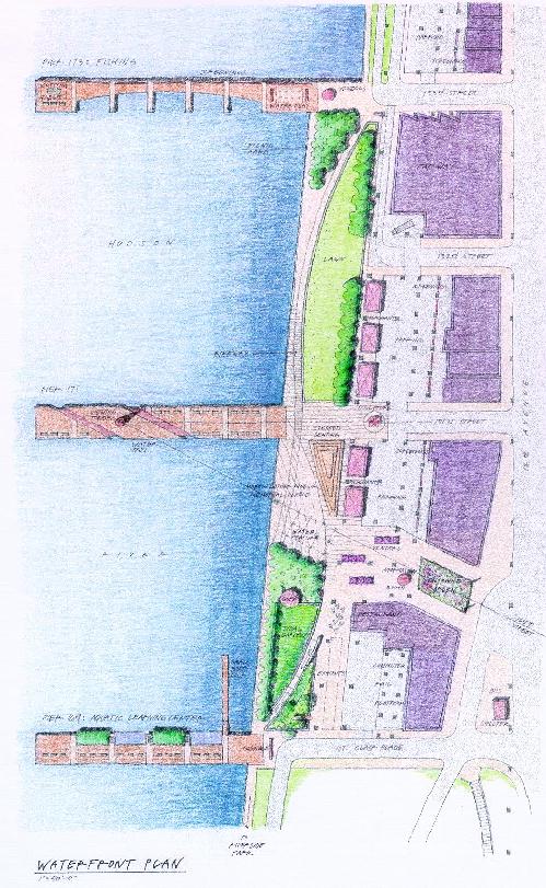
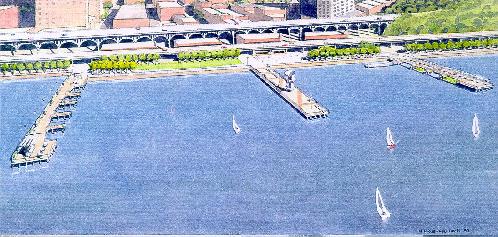
The area has a number of active uses, including auto-related activities, meat-packing and wholesale establishments, light industrial uses and a bus depot. Little recreation takes place along the riverfront except for fishing by local residents during the warmer months. The bulkhead along the Harlem Piers is in poor condition. A portion of the bulkhead collapsed (between St. Clair Place and 125th Street). That area was fenced off to protect the public and to allow the City to make repairs to the bulkhead.
The Fairway market is an active business located at Marginal Way and 131st to 133rd Streets. Fairway is leasing a portion of riverfront from the City on a month-to-month basis for accessory parking and it is working to negotiate a long-term parking lease.
Traffic lanes were added to Marginal Way and a traffic signal was installed at Marginal Way and 125th Street to control vehicular movement due to the increase in traffic to the Fairway market.
The Economic Development Corporation (EDC) released a Request for Proposals to develop the bulkhead immediately south of the Fairway parking area. Five proposals were submitted. EDC is currently reviewing the proposals.
Plans are underway by the Department of Parks and Recreation (DPR) to construct an esplanade south of the Harlem Piers area called Cherry Walk, which will terminate at St. Clair Place. In addition, DPR hired a consultant to develop a bicycle and pedestrian path along the Hudson River, including the Harlem Piers area, called Hudson Riverwalk. The consultant will develop a schematic design for an easement through the Harlem Piers area (St. Clair Place to West 135th Street).
As part of the consensus-building process, the steering committee reviewed nine plans developed by the community planning teams. Seven objectives emerged as common elements among the plans. These common elements were used to form the "planning and design framework" the goals and objectives by the consultant team to develop a draft composite plan.
Develop the Harlem Piers area as a local and regional resource by:
Based upon the planning and design framework the steering committee used the community plans and other sources to formulate recommendations in seven categories.
Economic Development improvements would help sustain the area as a local and regional destination, create jobs and business opportunities for local residents. The improvements would establish an 18-hour commercial district, which would consist of daytime wholesale and retail uses and after-hours entertainment and passive recreational uses. Fairway should remain in the area and should be perceived as the daytime anchor for the commercial corridor. All new commercial uses would provide potential revenue sources to the 125th Street Business Improvement District.
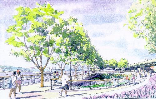
Parks and Open Space recommendations would increase the width of the riverfront park, offer more locations for activity; provide access to the river; increase the amount of passive recreation and connect into Riverside Park north and south.
Transportation and Parking recommendations would reduce pedestrian/vehicular conflict, increase the number of parking spaces available to present and future businesses such as Fairway, the Cotton Club and Smitty's Meat Market and it would improve access to the riverfront area.
Art, Culture & Education would introduce a theme for the district, offer educational opportunities to youth, engage artisans, musicians and caterers, capitalize on Northern Manhattan's diverse culture.
The Harlem Piers area is a special place. The Urban Design and Streetscape Improvements would make the area more cohesive, provide a physical and visual connection to the waterfront and celebrate the area as a special place.
Environmental Restoration improvements would increase the interaction with natural resources, expand the amount of green spaces and trees, introduce energy-efficient building design.
Protecting the History and Architecture would preserve the character of the area, protect view corridors and promotes the area's history.
| 4. Next Steps: Implementing the Vision |
| | Index | Overview | Harlem Piers | Harlem on the River | Next Steps | Appendix A | Acknowledgements | |
Implementing the vision will require site control, development funds, approvals from federal, state and municipal agencies. It will also require a development entity, relocation of certain businesses and an aggressive business attraction program to get certain businesses and uses to move into the area. Finally, it will require the on-going participation and support from local residents, elected officials, businesspeople and institutions.
Next Steps
| Appendix A: Green Building Design Standards |
| | Index | Overview | Harlem Piers | Harlem on the River | Next Steps | Appendix A | Acknowledgements | |
Provided by AIA, Committee on the Environment
| Acknowledgements |
| | Index | Overview | Harlem Piers | Harlem on the River | Next Steps | Appendix A | Acknowledgements | |
| Project Sponsors | |
| West Harlem Environmental Action, Inc. | |
| Manhattan Community Board 9 | |
| Harlem on the River Steering Committee | |
| Barbara Askins | 125th Street Business Improvement District |
| Stephen Campbell | City College Architectural Center |
| Cecil Corbin-Mark | West Harlem Environmental Action, Inc. |
| Fernando Fernandez | Empowerment Zone |
| Maritta Dunn | Community Board 9 |
| Hon. Herman D. Farrell, Jr. | New York State Assembly |
| Hon. C. Virginia Fields | Manhattan Borough President |
| Jim Hadley, AIA | AIA, Committee on the Environment |
| Tom Hoover | Fairway |
| John H. Johnson, III | NY League of Conversation Voters |
| Joyce Lee, AIA | AIA, Committee on the Environment |
| Edwin Marshall | Department of City Planning |
| Sarah Martin | Grant Houses |
| Charles McKinney | NYC Department of Parks and Recreation |
| Hon. Stanley Michels | New York City Council |
| Hon. Keith Mitchell | Community Board 9 |
| Hon. David A. Paterson | New York State Senate |
| Hon. Bill Perkins | New York City Council |
| Hon. Charles B. Rangel | U.S. House of Representatives |
| Roger Reynolds | Citibank |
| Gwendolyn Scott | Harlem Community Development Corporation |
| William Scott | Columbia University |
| Peggy Shepard | West Harlem Environmental Action, Inc. |
| Ernestine Welch | Community Board 9 |
| Geoffrey Weiner | Columbia University Facilities Management |
| Canon Frederick B. Williams | Church of the Intercession |
| Hon. Keith Wright | New York Assembly |
| Greg Watson | Harlem Congregations for Community Imp. |
| Planning Consultants | |
| Mitchell Silver | Abeles Phillips Preiss & Shapiro, Inc. |
| Ken Bowers | Abeles Phillips Preiss & Shapiro, Inc. |
| Thomas Balsley | Thomas Balsley Associates |
| Michael Koontz | Thomas Balsley Associates |
| Green Building Design Standards | |
| Jim Hadley | |
| Joyce Lee | |
| Special Thanks | |
| Evin Askay | |
| Damian Gaillard | |
| Carlos Jusino | |
| Dalece Lum | |
| Claudia Marte | |
| Alice McIntosh | |
| Xavier Morales | |
| Michael Springs | |
| Melissa Springs | |
Thelma Russell, Chase Manhattan Bank
Emily Lloyd of Columbia University and Yolanda Moses of City College for their support generous hospitality.
The Harlem Community Development Corporation for hosting the Steering Committee's monthly meetings.
This project was funded in part by the U.S. Department of Energy and the North River Settlement Fund.